NOAA
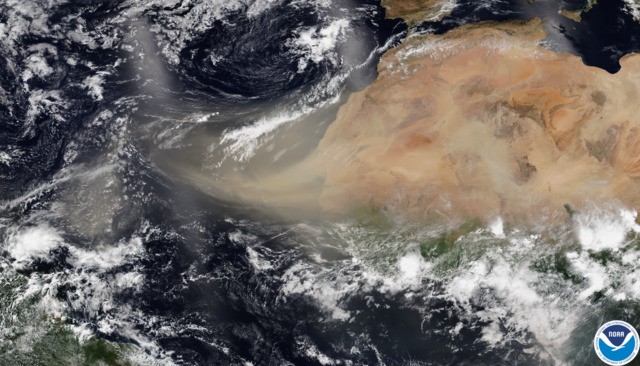
The Saharan Air Layer, or “plume,” made up of 800 million metric tons of dust particles — according to NASA — is visible from the International Space Station and can be seen on satellite images.
This past weekend, the plume made its way across the Caribbean, darkening skies and causing record level air quality warnings.
Health specialists have warned those struggling COVID-19-related respiratory symptoms to stay indoors and use air filters if available.
The plume will likely move into the Ohio Valley this weekend, predicts the Weather Channel and NOAA, also noting that the dust is "unusually dense."
Cleveland's National Weather Service also tweeted:A mass of very dry, dusty air is moving across the Atlantic right now.
— NOAA Research (@NOAAResearch) June 24, 2020
This NOAA animation predicts the movement of the #SaharanDust plume from now through Sunday evening (June 29).
Learn more about the #SaharanAirLayer: https://t.co/OJLrnuKiLI pic.twitter.com/yvPjiE5o91
On the bright side, we can expect stunning sunrises and sunsets due to the “scattered sunlight,” refracting vibrant shades of red, orange, yellow and pink.The much talked about #SaharaDust is across the #Caribbean and #GulfofMexico. It is moving towards the Southern #USA. The dust plume will move up towards the #Ohio Valley this weekend causing hazy skies. Here are some pictures from Puerto Rico.#OHwx #PAwx #NWS #Cleveland pic.twitter.com/kbYotxwGBE
— NWS Cleveland (@NWSCLE) June 24, 2020
"Dust plumes like these typically become less concentrated the farther to the west they move," weather.com senior meteorologist Chris Dolce said. "But the dust might at least contribute to hazy skies in some areas of the U.S. There could also be brilliant sunrises and sunsets."